


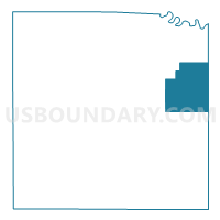
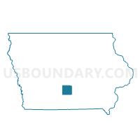
UNION TWP Voting District, Warren County, Iowa
About
Outline

Summary
| Unique Area Identifier | 583638 |
| Name | UNION TWP Voting District |
| County | Warren County |
| State | Iowa |
| Area (square miles) | 28.44 |
| Land Area (square miles) | 28.27 |
| Water Area (square miles) | 0.17 |
| % of Land Area | 99.41 |
| % of Water Area | 0.59 |
| Latitude of the Internal Point | 41.37986960 |
| Longtitude of the Internal Point | -93.36687440 |
Maps

Graphs
Select a template below for downloading or customizing gragh for UNION TWP Voting District, Warren County, Iowa


Neighbors
Neighoring Voting District (by Name) Neighboring Voting District on the Map
- BELMONT TWP W/O MILO Voting District, Warren County, IA
- FRANKLIN TWP Voting District, Marion County, IA
- LINCOLN TWP Voting District, Warren County, IA
- PALMYRA TWP Voting District, Warren County, IA
- PLEASANT GROVE TWP Voting District, Marion County, IA
- RICHLAND TWP Voting District, Warren County, IA
Top 10 Neighboring County Subdivision (by Population) Neighboring County Subdivision on the Map
- Pleasant Grove township, Marion County, IA (2,769)
- Lincoln township, Warren County, IA (2,343)
- Richland township, Warren County, IA (1,260)
- Belmont township, Warren County, IA (957)
- Palmyra township, Warren County, IA (559)
- Union township, Warren County, IA (496)
- Franklin township, Marion County, IA (320)
Top 10 Neighboring Place (by Population) Neighboring Place on the Map
Top 10 Neighboring Unified School District (by Population) Neighboring Unified School District on the Map
- Indianola Community School District, IA (19,742)
- Carlisle Community School District, IA (8,414)
- Pleasantville Community School District, IA (3,427)
- Southeast Warren Community School District, IA (3,051)
Top 10 Neighboring State Legislative District Lower Chamber (by Population) Neighboring State Legislative District Lower Chamber on the Map
- State House District 74, IA (33,724)
- State House District 73, IA (32,505)
- State House District 71, IA (30,841)
Top 10 Neighboring State Legislative District Upper Chamber (by Population) Neighboring State Legislative District Upper Chamber on the Map
Top 10 Neighboring 111th Congressional District (by Population) Neighboring 111th Congressional District on the Map
Top 10 Neighboring Census Tract (by Population) Neighboring Census Tract on the Map
- Census Tract 301, Marion County, IA (7,311)
- Census Tract 211, Warren County, IA (4,795)
- Census Tract 206, Warren County, IA (3,063)
- Census Tract 306, Marion County, IA (2,687)
- Census Tract 205, Warren County, IA (2,315)